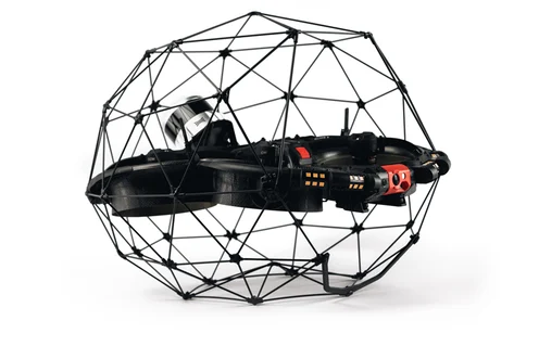
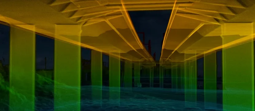
We recently teamed up with Flyability to put their innovative Elios 3 and its new LiDAR payload to the test by surveying a busy road bridge in Belgium. The challenge? To complete the survey without disrupting the flow of traffic. Safety Using the Survey Payload, we successfully mapped the entire 600 meters of the bridge, closely inspecting hard-to-reach areas without requiring workers to climb or perform risky tasks at height. Plus, the drone was operated in a way that didn’t cause any distractions to passing vehicles. Efficiency The Elios 3 managed to complete an outdoor survey of this bridge in just four flights, all within a single day. This approach eliminated the need to shut down roads or reroute traffic, saving both time and resources. Accuracy The Surveying Payload proved highly precise, collecting data to within 1 cm in over 90% of cases. This level of detail ensures reliable results that can guide future maintenance decisions. Business Impact Even though we couldn’t fly directly above the bridge deck due to safety concerns, we were still able to reconstruct the entire structure with remarkable precision using data collected from surrounding areas. In October 2023, Flyability introduced the Elios 3 Surveying Payload as part of their commitment to improving drone-based surveying capabilities. Partnering with us, Droprise, they set out to demonstrate how this advanced tool could transform road bridge inspections in Belgium. Drone operators now have two distinct options when choosing the Elios 3’s LiDAR payload. The standard Rev 6.2 LiDAR offers a good balance between cost and functionality, suitable for general area assessments. Meanwhile, the Surveying Payload, equipped with the Rev 7 LiDAR, excels in situations demanding extreme precision—ideal for intricate environments like mine shafts, sewer systems, and bridges. This payload leverages enhanced hardware and specialized software from FARO Connect to deliver exceptional performance. During tests, over 90% of collected data achieved accuracy within 2 cm, with up to 1.3 million points captured per second. Processing with FARO Connect streamlined data alignment and minimized noise, ensuring clean and actionable outputs. In October 2023, Droprise joined forces with Flyability to deploy the Surveying Payload on-site and validate its potential in diverse mapping scenarios. Since 2019, Droprise has been a trusted distributor of Flyability products in Belgium, witnessing firsthand the evolution of the Elios series—from the original Elios 1 to today’s state-of-the-art Elios 3. Our expertise lies in drone-based inspections for construction and infrastructure projects, based out of Bruges. To convince skeptical clients about the Elios 3’s merits, we needed concrete evidence showcasing its practical value. Thus, we identified a perfect opportunity—a bridge survey along a major motorway section where halting traffic wasn’t feasible. LiDAR technology reveals detailed insights into bridge structures. Our team received authorization to assess critical sections of the bridge without obstructing traffic. Flying overhead was prohibited, so we focused on collecting data from beneath and beside the structure. This bridge, constructed in 2014, spans both land and waterways frequented by vessels daily. While structurally sound, accessing its underside remains impractical without constructing temporary scaffolding. Hence, this location perfectly highlighted the Elios 3’s advantages—providing seamless access without complications. High-definition LiDAR visuals reveal bridge intricacies in stunning clarity. The 600-meter span was thoroughly examined across multiple angles in just four flights. Pilots ensured safe distances from active lanes while maintaining close proximity to the underside to gather sufficient data. Despite the Rev 7 LiDAR registering 1.5 million points per second, resulting in dense point clouds, the live FlyAware model confirmed comprehensive coverage. Post-flight processing via FARO Connect aligned datasets and generated a precise 3D representation of the bridge. The final point cloud image produced from these flights demonstrates remarkable clarity and structural detail, offering a holistic view even though data was collected from limited perspectives. Such high-quality imagery serves as compelling proof for potential clients, especially those managing large-scale infrastructure projects nationwide. In the near future, Droprise plans to conduct additional flights that will incorporate georeferencing techniques. By harnessing the Surveying Payload’s superior accuracy alongside FARO Connect’s automation tools, we aim to create highly localized models accurate to within centimeters. This initiative underscores our dedication to advancing digital transformation within the Belgian infrastructure sector. Ningbo Senmiao Trading Co., Ltd. , https://www.nbsenmiao.comMapping a 600-meter Bridge with the Elios 3 Surveying Payload
Understanding the Elios 3 LiDAR Options
 With the new Surveying Payload, the Elios 3 pushes boundaries beyond traditional surveying methods.
Surveying a Road Bridge Without Halting Traffic
Unparalleled Results from Drone-Based Bridge Inspections